-
• #428
There are some cheaper tracking devices that can produce a gpx file. I'm probably showing weak searching abilities but they seem quite hard to find, especially those with slightly longer battery life. There's a list here (from a compatibility list for an app that can extract gpx files from different devices):
http://www.mytracks4mac.com/c/index.php?option=com_content&view=article&id=70&Itemid=466&lang=en
I know that the navi MiniHomer and Holux have been used specifically for cycling. No idea about the others. May come back to this list.
-
• #429
I've got a Holux 260GPSport Pro, it's not bad. Finds GPS pretty quick usually (sometimes struggles for a minute or two when I'm leaving work, what with big tall city buildings around). It's got ANT+ stuff, so can do heart rate and cadence. Doesn't automatically upload to strava, you've got to use Holux's program to save the ride as a .gpx then upload that.
Generally it's great, no dodgy tracking (as I see on a lot of garmin strava tracks, think it's smart record or whatever it's called that gives people KOMs with speeds they never get near and only actually logs their position every 6 seconds).
Also, ridden it through all kinds of shit weather and no water ingress or anything to complain about. I picked it up for £70 but I think it's gone up a bit since then...
-
• #430
I've just bought the Cateye Steal 50.
So far I like it, the tracking looks a bit odd in places, placing me cycling through buildings. But generally it's pretty quick to pick up the satellites, and has all the functionality I need at a price point well south of the Garmins.
-
• #431
Does anyone know if Strava will accept GPS coordinates including altitude from altimeter-equipped GPS devices other than Garmin? From what I understand Strava uses only latitude-longitude from smartphones and GPS without altimeters, and latitude-longitude-altitude for specific Garmin models.
-
• #432
Does anyone know if Strava will accept GPS coordinates including altitude from altimeter-equipped GPS devices other than Garmin? From what I understand Strava uses only latitude-longitude from smartphones and GPS without altimeters, and latitude-longitude-altitude for specific Garmin models.
If it doesn't open the gpx file in excel and strip out the unecessary data
-
• #433
Just bought an eTrex 20 after seeing various glowing reviews on here... now, will the open source maps (http://talkytoaster.info/ukmaps.htm) do me well enough or would the general recommendation be to bite the bullet and buy the proper ones? Any other advice for a novice eTrex user greatly appreciated...
Cheers
-
• #434
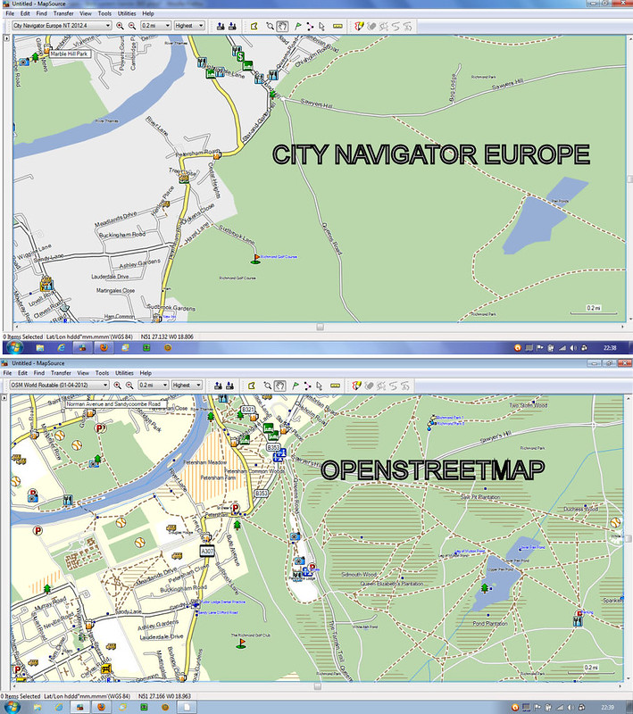
Use the open source maps; I use them on my edge 800 and my etrex and prefer them to both the city navigator europe and the garmin OS maps
-
• #435

-
• #436
Thanks mate - that's great to hear. Did you get yours from this talkytoaster or would you recommend another option?
Cheers
Use the open source maps; I use them on my edge 800 and my etrex and prefer them to both the city navigator europe and the garmin OS maps
-
• #437
I usually get them from here http://garmin.openstreetmap.nl/ which is where talkytoaster obtain them.
-
• #438
Ah, got it, I had found that link elsewhere as well I think - the level in detail between the two examples you provide above is incredible! Open source definitely seems the way to go... are there any likely 'glitches' or bugginess that come with it or just those that you get with any/all GPS device?
Thanks again
I usually get them from here http://garmin.openstreetmap.nl/ which is where talkytoaster obtain them.
-
• #439
The only very slight downside is that with the city navigator maps you can do a post code search, this does not work with OSM. You can though still use address look up/search in the "where to " menu.
In reality I have never wanted or needed to do a post code look up, there are so many other options. -
• #440
I have just returned from a 5 day trip to Belgium where I used a GPS app on my iPhone called NavFree (Benelux). This worked perfectly without needing for my internet to be turned on, and always showed me exactly where I was. It worked better in the countryside, but also in the cities, if a little slower.
The route option does select the fastest route to where you want to go, but it you fancy changing that route when you spot a nice road you want to go down it will recalculate your route quickly. It was lovely to not have to carry a map, and to have it all on your phone. Furthermore it have places of interest saved in it (if you want to look for a nearby hotel or rail station) and didn't run down my battery noticeably. So long as I charged every evening I was fine.
It may have been that where I was, North Belgium, is so flat that the GPS worked perfectly, but still, even when it didn't (such as when I was on a train) I still had the maps which was good enough.
It didn't have any cycling features (obviously) but it was great just for directions and exploring.
TLDR: If you're going abroad (or even in the UK) and don't want to unfold maps all the time and can't afford to have your internet turned on abroad, then download NavFree for the country you're going to.
-
• #441
This looks like an original and well thought out idea.
What do you think?
http://www.dragoninnovation.com/proj...ign=hammerhead
For a good price you get a navigation system for your bike that you can link to maps, either through Strava or the proprietary app. It stores the maps so you can continue to navigate without mobile connection.
Seems like a good navigational tool if you don't want to shell out a hundred quid+ on a Garmin or similar?
-
• #442
-
• #443
Garmin Connect is hanging today (even more than usual). Anyone else finding this?
-
• #444
http://bikeroutetoaster.com/Default.aspx is offline due to Google removing their v2 API.
Is there an alternative that will allow me to get turn-by-turn navigation into the LOL audax route gpx?
-
• #445
-
• #446
Which gps do you have? The 800 and 810 do this as part of the conversion from GPX to FIT.
-
• #447
800
-
• #448
I've added gpx files before and they don't give turn-by-turn warnings. It may have been because I didn't enable them but I've always run files through bikeroutetoaster until now.
-
• #449
I've added gpx files before and they don't give turn-by-turn warnings. It may have been because I didn't enable them but I've always run files through bikeroutetoaster until now.
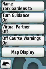
When people do not get turn by turn directions as you intimate it is because this has not been enabled in the course settings.
For general info this is not a global setting and turn guidance needs to be set to on, individually for each course.

-
• #450
I had TBT working on a course yesterday and then it just kinda stopped mid-ride. I stopped the course and restarted it and I started to get TBT again.
 hippy
hippy pastry_bot
 TurtleRecall
 christofk
 freezing77
 owl
owl fredtc
 jimalex
 dimi3
dimi3 miro_o
I use a Garmin Dakota http://www.amazon.co.uk/dp/B002G1YPIE/?tag=hydra0b-21&hvadid=9556645389&ref=asc_df_B002G1YPIE
Not a specific cycling GPS but you can get a bike mount and you can customise the display to show you what you want.
If you want heart-rate monitor, cadence, etc you need the Dakota 20 with Ant+
You can use free open street map maps for on-the-fly routing, etc.
Bit of a ball-ache in that it doesn't upload automatically to Strava/Garmin Connect, you manually have to upload the GPX file (it used to work OK but on later versions of the firmware this suddenly stopped working, probably to encourage more sales of the running/cycling specific ones).
For getting google maps routes into GPS I've always used this http://www.elsewhere.org/journal/gmaptogpx/