-
• #602
500 has ant+ support.
yeah, i don't need heart monitor so 200 should be fine.
-
• #603
I thought you couldn't navigate with 500? It doesn't come with basemaps
-
• #604
I thought you couldn't navigate with 500? It doesn't come with basemaps
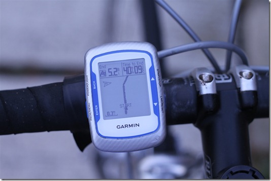
You do not need maps to navigate, just go in the direction of the pointer.

Good info here http://www.dcrainmaker.com/2009/12/garmin-edge-500-in-depth-review.html -
• #605
Is there an easy way to crop routes, for example, I leave mine running when I stop (say for lunch) in case I forget to start it again, is there a way to cut out the stop time? Also, on the recent sail to Brighton, I forgot to stop it when getting on the train, which resulted in impressive 90mph top speed, but I would rather crop the end off?
-
• #606
I use basecamp to manipulate the gpx file, you can also do this manually in a text editor such as notepad.
http://www.gpsvisualizer.com/ will convert the fit file on your device to a gpx file for editing. -
• #607
I'll have a look when I get home, cheers.
-
• #608
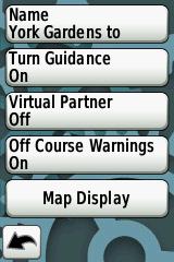
For each course you download you need to set the course attributes, I would suggest something like this.

By default turn guidance is off, there is no way to turn it on as a global setting. Another garmin quirk.
Hmm. Just navigated across the city no problems. Downloaded a gpx from RWGPS and it gave me two warnings before turns, with te road names and arrows and such. When I went off course it recalculated pretty fast... Maybe it's set up right as default?
Edit: I don't use any garmin software to install the files, just dragged them into the gpx folder.
-
• #609
Same and I've always had to turn on, turn-by-turn.
What firmware do you have? Maybe they've fixed it?
-
• #610
The latest I believe, 3.30. There were a lot of changes on the update log.
Edit: is there a reason why it would recalculate a "navigate to here" ride even if you don't go off course? I let the garmin guide me home (thought it would fail miserably) but it did quite well apart from recalculating sometimes and leaving me in the dark for 3 mins at a time..
-
• #611
Got this message trying to upload an activity file:
 Some activities could not be created. View all activities
Any ideas how to make it work?
-
• #612
Got this message trying to upload an activity file:
 Some activities could not be created. View all activities
Any ideas how to make it work?
Do a manual upload.
Browse to your activities folder and choose the requisite fit files -
• #613
i've got a second hand edge 705 and apparently it doesn't create the .tcx files in the history folder... the laps are ok but no .tcx files at all...
i tried already to master reset it and downgrade the firmware but it does't want to work... did it happen to anybody? -
• #614
Is there a way to mark a point on the map whilst riding? ie. say I spot a pothole I want to report and want to mark it as a waypoint on the Garmin - how? Clicking or double clicking while in free zoom on the 800 drops a little red pin on the map but it seems to vanish.
-
• #615
Lap button?
-
• #616
iIf you press and hold the gps signal indicator it will mark a waypoint at your current position.
Mark location
-
• #617
GPS signal indicator? Where do I find that?
-
• #618
On the main menu page
-
• #619
So, click and hold the bars at the top left? I'll give it a go, ta.
-
• #620
Yep
Maybe hold is not quite the correct term press for a couple of seconds then release
1 Attachment
-
• #621
You do not need maps to navigate, just go in the direction of the pointer.

Good info here http://www.dcrainmaker.com/2009/12/garmin-edge-500-in-depth-review.htmlwill the pointer take me to the start of my route, or do I have to get to that myself?
-
• #622
I am unsure on the 500 but if it is like other gps units it will make a straight line from your current position to the start of the track. Alternatively if you know this is going to be the case make a new track to the start of the original track or easier still make a complete new track using bikely, ridewithgps, garmin connect etc.etc. etc.
-
• #623
Is there a way to mark a point on the map whilst riding? ie. say I spot a pothole I want to report and want to mark it as a waypoint on the Garmin - how? Clicking or double clicking while in free zoom on the 800 drops a little red pin on the map but it seems to vanish.
LOL Got some spare time? Spare few weeks. You'll need it.
-
• #624
Just to check, when routing on the 800, it needs to be set to walking to avoid A roads/motorways? Anything else that needs to be adjusted?
-
• #625
LOL Got some spare time? Spare few weeks. You'll need it.
Not all of them, shit I'd never ride anywhere, just the most evil ones.
 bitterbuffalo
 Jec
Jec freezing77
 TM
TM Kidneys
 hippy
hippy dave4
dave4 Breso
Breso NotThamesWater
 @big_daddy_wayne
I do that all the time, 200 and 500 are essentially the same, 500 has ant+ support. The way I do it is create and load a course from garmin connect. Works fine for me.