-
http://ridewithgps.com/routes/6082116
Some of the roads between the suitably named Killin and Glencoe were a little busy, lots of buses and lorries but I think these things are unavoidable in some mountainous areas. The Glencoe Pass is worth the prior 40km of big roads anyway. Also worth noting the Old Military Road between Kinlochleven and Fort William would be unpassable on normal touring tyres. I was pushing up parts with 1.8" tyres.

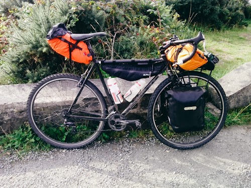
In terms of packing it was pretty much one pannier of clothing (1 change of base layers plus a windproof shirt, arm/leg warmers, down jacket and a waterproof) and one pannier of other bits (stove, paper map, wash bag, washing line). Food was then split over the two panniers. In the saddle bag I took my tent and on the dry bag on the front rack was a sleeping mat and my sleeping bag. Frame bag took mostly tools, spares and snacks.
Mostly followed my Garmin (Edge 200) for route finding, which I was charging via dynamo hub. Charged very quickly, 30 minutes a day connected was enough to see me through to the following morning. Then used my phone for photos and finding shops and food through the app OsmAND, which is offline vector maps which you can then apply layers over in order to display different services (shops, restaurants, toilets, petrol stations, etc). Useful when you are likely to have no phone signal. There's a free version which is completely functional but it was so handy I think I'll show some support and buy the full thing.
First proper tour and not too much went wrong. Next time I'd probably get a cassette with a wider range as the Applecross climb was pretty tough loaded, even with a triple. I think I'm going to invest in one of Soma's low trail forks some time over winter too.
You are reading a single comment by @Jon. and its replies.
Click here to read the full conversation.
 Jon.
Jon. nauls
nauls
Looks amazing. Interested in your route if you have a record of it?